Mobile Vehicle-mounted 3D Mapping Scanner
next
prev
Video
1/2

Mobile Vehicle-mounted 3D Mapping Scanner

Price
MOQ
$18999
1 Pieces
Product Details
Scanning Accuracy:
±5cm @ 200m
Scanning Speed:
3,000,000 points per second
Compatible Vehicles:
Pickup Trucks, SUVs and Other Passenger Vehicles
Shipping & Policy
Shipping & Delivery Info:
Contact the supplier for details on freight charges and estimated delivery time—tailored to your order and shipping requirements.
Payment Methods:
T/T PayPal
Support payments in USD
Transaction Security Guarantee:
Our platform strictly verifies suppliers’ and buyers’ qualifications to ensure authenticity & legitimacy, creating a reliable trade environment and reducing risks.
After-Sales Support:
For issues like mismatched product quality or delivery delays, we offer assistance—intervening to coordinate and resolve problems per contracts/rules, safeguarding your rights.
Our Store's Similar Products
Product Description
Company Info

Basic Info

This mobile vehicle-mounted 3D mapping scanner is designed for road survey, urban road mapping, municipal facility survey and other mobile survey scenarios. It is mounted on the roof of passenger vehicles, and can realize high-efficiency dynamic scanning during driving, solving the problems of low efficiency and high cost of traditional manual road survey. It can quickly obtain 3D point cloud data of large-scale road and urban areas, providing accurate basic data for road construction, urban planning and municipal management.

Key attributes

Scanning Accuracy
±5cm @ 200m
Scanning Speed
3,000,000 points per second
Compatible Vehicles
Pickup Trucks, SUVs and Other Passenger Vehicles
Dynamic Scanning Speed
0-60km/h Dynamic Scanning Support
Power Supply
Vehicle-mounted 12V/24V Power Supply
Protection Rating
IP67 Dust and Water Resistant
Positioning System
GNSS High-precision Positioning
Export File Formats
LAS, LAZ, DSM, DEM
Compatible Software
Road Survey Modeling Software, Urban Planning Tools
Multi-sensor Fusion
Laser + HD Camera Fusion Positioning
Working Temperature
-20℃ to 60℃

Customer reviews

David · Transportation Infrastructure Planner
The Mobile Vehicle-mounted 3D Mapping Scanner has transformed how we conduct road network surveys. Mounted on our survey vehicle, it captures high-definition 3D data of roads, bridges, and surrounding infrastructure at traffic speed. The system's ability to collect accurate data without lane closures is invaluable. The point cloud quality exceeds our expectations, and the processing software is intuitive and powerful.

Product Description

Product features:

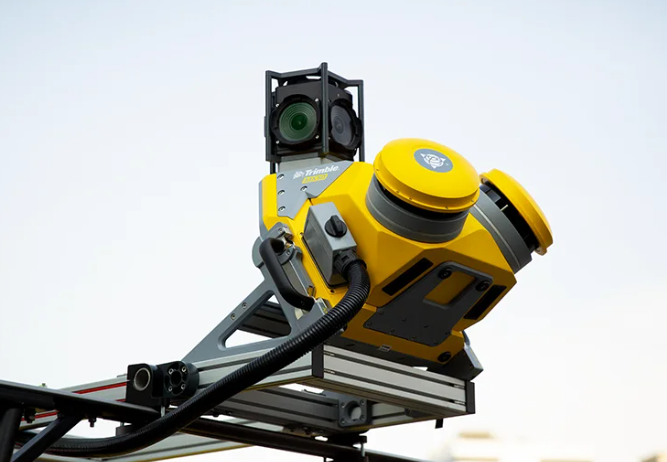
This product supports dynamic scanning at a speed of 0-60km/h, which can complete the survey of 10 kilometers of roads per hour, greatly improving the efficiency of road survey. It adopts multi-sensor fusion technology of laser and HD camera, which can obtain more detailed scene information and improve the accuracy of scanning data. It is equipped with GNSS high-precision positioning system, which can accurately record the position of scanning data. The IP67 protection rating can adapt to various harsh outdoor environments, and the vehicle-mounted 12V/24V power supply can realize long-time continuous work. It is compatible with mainstream road survey modeling software, providing one-stop solution for road survey and modeling.

https://globalsyt.oss-accelerate.aliyuncs.com/materials/182/0/20260306105520_69aa421847968.PNG

Product specifications:

The scanning accuracy is ±5cm at 200m, with a scanning speed of 3 million points per second. It supports dynamic scanning at a speed of 0-60km/h, and can complete the survey of 10 kilometers of roads per hour. It is compatible with pickup trucks, SUVs and other passenger vehicles, and is equipped with a quick-release mounting bracket that can be installed on the vehicle roof in 10 minutes. It is powered by the vehicle-mounted 12V/24V power supply, and has no working time limit. The protection rating is IP67, and the working temperature range is -20℃ to 60℃. It adopts GNSS high-precision positioning system and multi-sensor fusion technology of laser and HD camera, and supports exporting files in LAS, LAZ, DSM and DEM formats. It is compatible with mainstream road survey modeling software and urban planning tools.

Product application:

This product is suitable for road survey, urban road mapping, municipal facility survey, land development and utilization survey, traffic accident site survey and other mobile survey scenarios. It is widely used in municipal management departments, highway construction companies, survey and design institutes and other enterprises and institutions engaged in road and urban survey businesses. It can replace traditional manual road survey, greatly reducing labor intensity and shortening the project cycle.

Frequently Asked Questions (FAQ)

Q:What makes Mobile Vehicle-mounted 3D Mapping Scanners suitable for highway surveys?
A:Equipped with SLAM technology, they map at 80km/h with 5cm absolute accuracy, capturing road assets (signs, markings) and pavement defects. Data integrates with CAD for smart transportation systems, achieving 95% automation in inventory audits.

Company Profile

Business Type:
Manufacturer
Main Products:
Conventional surveying instruments,Electronic components,Architectural decoration instruments,
Year of Establishment:
2010
Number of Employees:
Address:
268-1 Youyi East Road, Beilin District, Xi'an, Shaanxi, China
Average Response Time:
Days

General Information

Business Type:
Manufacturer
Main Products:
Conventional surveying instruments,Electronic components,Architectural decoration instruments,
Year of Establishment:
2010
Number of Employees:
Management System Certification:
HACCP,TL900,QS9000,SA8000,ISO9001,ISO9004,ISO17799,ISO9000,ISO14000,ISO10441,ISO16949,TS16969,ISO19011:2000,OHSAS18001,Others
Address:
268-1 Youyi East Road, Beilin District, Xi'an, Shaanxi, China

Trade Capability

Main Markets:
北美,南美洲,东欧,东南亚,非洲,大洋洲,中东,东亚,西欧,中美洲,北欧,南欧,南亚,国内市场
Shipping Ports:
Export Volume:
Average Lead Time:
Days
Payment Terms:
T/T L/C MoneyGram PayPal D/P Western Union Others
Cooperation Mode:
OEM
Customization Supported:
Yes
Number of Foreign Trade Sales Staff:
Overseas Agent / Overseas Branch:
No

Company Show

Contact this supplier now
*From:
*To:
Mr. Zhang Jianmin
manager /
*Message:
Send
New Products
Product Groups
Find Similar Products By Category
scroll_to_top