


This drone-mounted 3D scanner can be quickly mounted on most mainstream industrial drones, requiring no complicated debugging procedures. It supports RTK real-time kinematic positioning, ensuring high-precision geographic data collection. It has a 5G real-time transmission function, enabling users to view the scanned point cloud data in real time during the flight. The built-in 512GB SSD storage can store massive amounts of survey data, and its IP67 protection rating ensures stable operation in harsh outdoor environments such as strong winds or light rain. It supports compatibility with Pix4D and other professional aerial surveying software, enabling fast generation of orthophoto maps and 3D terrain models.
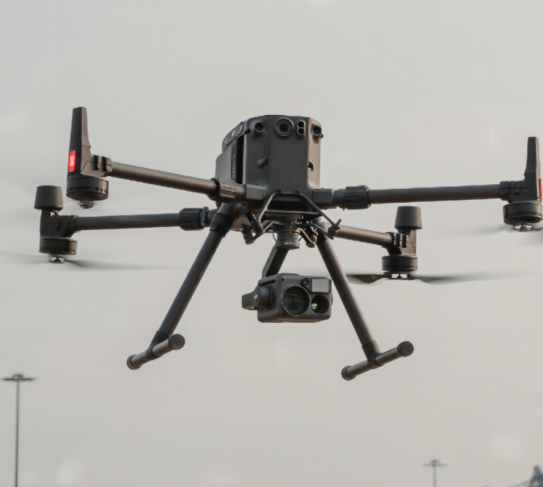
The drone-mounted aerial 3D mapping scanner is compatible with DJI Matrice 300, Autel Dragonfish and other mainstream industrial drones, and can be quickly installed without modifying the drone body. It has a scanning width of 50m when flying at an altitude of 100m, with a scanning accuracy of ±5 cm at 100m, meeting the needs of large-scale terrain surveying. The flight altitude range is 50m to 200m, adapting to different surveying scales. It is equipped with a built-in 512GB SSD for data storage, and supports 5G real-time data transmission, enabling users to remotely view the scanning progress and data. The total weight of the device is 2800 grams, and its IP67 protection rating ensures stable operation in outdoor environments with wind speeds of up to level 6. It supports compatibility with Pix4D and other professional aerial surveying software, enabling fast generation of orthophoto maps and 3D terrain models.
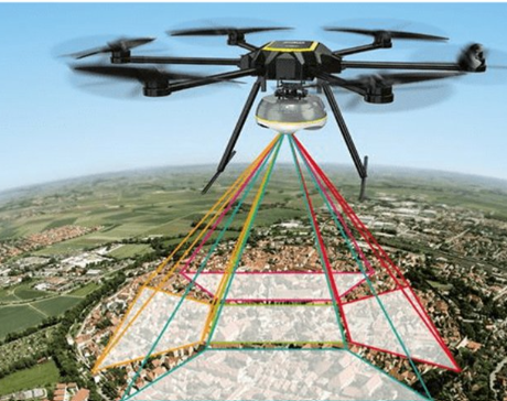
This scanner is widely applicable to large-scale terrain surveying, mine reserve monitoring, garden green space planning, post-disaster disaster assessment and other large-scale outdoor surveying scenarios. For land surveying enterprises, it can quickly complete the surveying of hundreds of acres of land, greatly improving the efficiency of geographic information collection; for disaster assessment departments, it can quickly scan the disaster area after earthquakes or floods, providing accurate data for disaster relief work; for garden planning departments, it can conduct detailed surveying of green spaces, providing data support for garden design.


 Post RFQ


 Chat
Chat


 ALL CATEGORIES