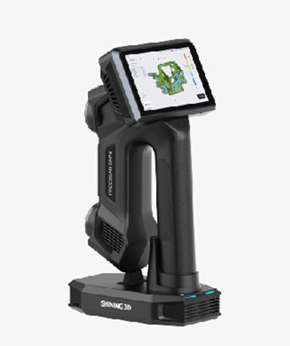
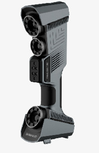


This handheld scanner features targetless automatic point cloud registration, eliminating the need for manual marker placement and reducing post-processing time. Its IP65 water and dust resistance makes it suitable for use in harsh outdoor field environments, including rainy or dusty construction sites. The built-in 10000mAh battery provides up to 8 hours of continuous working time, supporting full-day field survey operations. It is fully compatible with mainstream surveying and CAD software such as AutoCAD, Revit, and CloudCompare, allowing users to directly import scanned data into existing project workflows. The compact, lightweight design enables one-handed operation, making it ideal for complex, hard-to-reach scanning scenarios.
The scanner delivers a scanning accuracy of ±0.1mm at a 0.5m working distance, with a maximum scanning speed of 1.2 million points per second. It supports a ranging distance range of 0.1m to 50m, and has a total device weight of 850g including the handheld grip. The built-in 10000mAh rechargeable battery provides up to 8 hours of continuous use, with a fast charging time of 2 hours via USB-C. It supports USB3.0 and Type-C data interfaces for fast file transfer, and its body is constructed from aviation aluminum alloy for durability. The device has an IP65 protection rating, making it resistant to dust and low-pressure water jets. It supports multiple common 3D file formats, including .ply, .obj, .stl, and .las, for seamless integration with existing digital twin workflows.
This portable handheld 3D mapping scanner is suitable for architectural survey and as-built drawing creation, cultural heritage site documentation and digitization, mechanical component inspection and reverse engineering, forest inventory and ecological survey, and event venue spatial mapping. Surveyors can use it to quickly collect site data for construction projects, while cultural heritage conservators can create high-fidelity digital models of archaeological relics and historic buildings. Manufacturing teams can use it to inspect the dimensional accuracy of machined parts, and event planners can create accurate spatial maps of event venues for layout and design.


 Post RFQ


 Chat
Chat


 ALL CATEGORIES