Backpack Mobile 3D Mapping & Survey Scanner
next
prev
Video
1/2

Backpack Mobile 3D Mapping & Survey Scanner

Price
MOQ
$69999
1 Pieces
Product Details
built_in_GNSS:
GPS/GLONASS/BeiDou
scanning_accuracy:
±2cm@10m
scanning_range:
0.5m to 100m
Shipping & Policy
Shipping & Delivery Info:
Contact the supplier for details on freight charges and estimated delivery time—tailored to your order and shipping requirements.
Payment Methods:
T/T PayPal
Support payments in USD
Transaction Security Guarantee:
Our platform strictly verifies suppliers’ and buyers’ qualifications to ensure authenticity & legitimacy, creating a reliable trade environment and reducing risks.
After-Sales Support:
For issues like mismatched product quality or delivery delays, we offer assistance—intervening to coordinate and resolve problems per contracts/rules, safeguarding your rights.
Our Store's Similar Products
Product Description
Company Info

Basic Info

This backpack mobile 3D mapping and survey scanner is designed for large-scale outdoor mobile survey, including city street mapping, scenic area digitization, and road network survey. It addresses the pain points of traditional ground survey tools that require long working hours and limited mobility for large-area outdoor surveys. Integrated with built-in GNSS positioning modules and high-precision laser scanning modules, it delivers accurate 3D point cloud data during mobile walking survey, enabling users to create high-resolution digital twin models of large outdoor areas quickly. Suitable for urban survey teams, tourism development companies, and transportation departments, this device streamlines large-scale outdoor spatial data collection and reduces project costs.

Key attributes

built_in_GNSS
GPS/GLONASS/BeiDou
scanning_accuracy
±2cm@10m
scanning_range
0.5m to 100m
device_weight
3.8kg including backpack rig
battery_capacity
20000mAh × 2
working_duration
10 hours
data_storage
2TB internal SSD
data_interfaces
Thunderbolt 4
protection_rating
IP53
supported_software
CloudCompare, RealityCapture

Customer reviews

Emma · Utility Mapping Technician
The Backpack Mobile 3D Mapping & Survey Scanner is ideal for urban infrastructure documentation. Its SLAM technology allows us to walk through streets and tunnels while continuously capturing data. During an underground utility mapping project, we collected 3km of tunnel geometry and asset locations in just two hours, with all data automatically georeferenced. The system's ability to work in GPS-denied environments makes it indispensable for our municipal surveys.

Product Description

Product features:

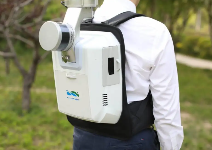
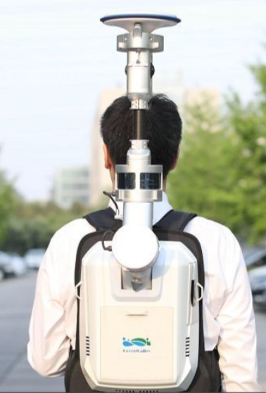
This backpack mobile scanner features built-in GPS/GLONASS/BeiDou GNSS positioning modules, allowing users to collect accurate spatial positioning data during mobile survey operations. It has a long working duration of up to 10 hours with two 20000mAh rechargeable batteries, supporting full-day outdoor survey operations. The 2TB internal SSD provides ample storage space for large-scale point cloud data, and the Thunderbolt 4 data interface allows for fast file transfer after survey operations. Its IP53 protection rating makes it resistant to light rain and dust, making it suitable for use in outdoor environments. The device supports automatic point cloud stitching and registration, reducing post-processing time and improving workflow efficiency.

https://globalsyt.oss-accelerate.aliyuncs.com/materials/182/0/20260306113519_69aa4b77dc689.png

Product specifications:

The scanner delivers a scanning accuracy of ±2cm at a 10m working distance, with a scanning range of 0.5m to 100m. It has a total device weight of 3.8kg including the backpack rig, and is powered by two 20000mAh rechargeable batteries that provide up to 10 hours of continuous working time. It has a 2TB internal SSD for large-capacity data storage, and supports Thunderbolt 4 data interfaces for fast file transfer. The device has an IP53 protection rating, making it resistant to light rain and dust, and is compatible with major 3D mapping software such as CloudCompare and RealityCapture. It supports built-in GNSS positioning for accurate spatial data collection, and features automatic point cloud stitching and registration for streamlined post-processing.

Product application:

This backpack mobile 3D mapping scanner is ideal for urban street view mapping and digital city creation, scenic area digitization and tourism development, road network survey and transportation planning, cultural heritage site outdoor documentation, and emergency disaster area mobile survey. Urban survey teams can use it to create accurate street view maps for digital city projects, while tourism development companies can use it to digitize scenic areas for virtual tourism applications. Transportation departments can use it to survey road networks for planning and maintenance, and cultural heritage conservators can use it to document large outdoor archaeological sites.

Frequently Asked Questions (FAQ)

Q:Why use a Backpack Mobile 3D Mapping Scanner for urban surveys?
A:Backpack systems enable walking-speed data collection (3-5km/h) with 360° SLAM technology, capturing streetscapes, tunnels, or forests where vehicles/drones can't operate, achieving 2-10cm positional accuracy.

Company Profile

Business Type:
Manufacturer
Main Products:
Conventional surveying instruments,Electronic components,Architectural decoration instruments,
Year of Establishment:
2010
Number of Employees:
Address:
268-1 Youyi East Road, Beilin District, Xi'an, Shaanxi, China
Average Response Time:
Days

General Information

Business Type:
Manufacturer
Main Products:
Conventional surveying instruments,Electronic components,Architectural decoration instruments,
Year of Establishment:
2010
Number of Employees:
Management System Certification:
HACCP,TL900,QS9000,SA8000,ISO9001,ISO9004,ISO17799,ISO9000,ISO14000,ISO10441,ISO16949,TS16969,ISO19011:2000,OHSAS18001,Others
Address:
268-1 Youyi East Road, Beilin District, Xi'an, Shaanxi, China

Trade Capability

Main Markets:
北美,南美洲,东欧,东南亚,非洲,大洋洲,中东,东亚,西欧,中美洲,北欧,南欧,南亚,国内市场
Shipping Ports:
Export Volume:
Average Lead Time:
Days
Payment Terms:
T/T L/C MoneyGram PayPal D/P Western Union Others
Cooperation Mode:
OEM
Customization Supported:
Yes
Number of Foreign Trade Sales Staff:
Overseas Agent / Overseas Branch:
No

Company Show

Contact this supplier now
*From:
*To:
Mr. Zhang Jianmin
manager /
*Message:
Send
New Products
Product Groups
Find Similar Products By Category
scroll_to_top