Industrial-grade Fixed 3D Mapping Scanner
next
prev
Video
1/2

Industrial-grade Fixed 3D Mapping Scanner

Price
MOQ
$49999
1 Pieces
Product Details
scanning_accuracy:
±0.02mm per 1m
max_scanning_area:
10m×8m
sensor_configuration:
dual-line laser + high-resolution camera
Shipping & Policy
Shipping & Delivery Info:
Contact the supplier for details on freight charges and estimated delivery time—tailored to your order and shipping requirements.
Payment Methods:
T/T PayPal
Support payments in USD
Transaction Security Guarantee:
Our platform strictly verifies suppliers’ and buyers’ qualifications to ensure authenticity & legitimacy, creating a reliable trade environment and reducing risks.
After-Sales Support:
For issues like mismatched product quality or delivery delays, we offer assistance—intervening to coordinate and resolve problems per contracts/rules, safeguarding your rights.
Our Store's Similar Products
Product Description
Company Info

Basic Info

This industrial-grade fixed 3D mapping scanner is designed for large-scale mechanical manufacturing, aerospace parts inspection, large steel structure survey and other high-precision industrial scenarios. It focuses on ultra-high precision and large-format scanning capabilities, realizing full-size inspection and reverse modeling of industrial parts, solving the pain points of low efficiency and insufficient accuracy of traditional inspection methods, and providing digital quality inspection and reverse engineering solutions for industrial production.

Key attributes

scanning_accuracy
±0.02mm per 1m
max_scanning_area
10m×8m
sensor_configuration
dual-line laser + high-resolution camera
real_time_point_processing
1,000,000 points/second
protection_rating
IP67
interface_types
Ethernet, PCIe
software_compatibility
SolidWorks, CATIA, Autodesk Inventor
dust_and_water_resistant
fully sealed for industrial workshop
modular_configuration
optional add-on scanning heads
laser_safety_class
Class 1 (eye-safe)

Customer reviews

Emily · Topographic Survey Technician
The UAV-mounted 3D Mapping Scanner revolutionizes our land surveying workflow. Mounted on our commercial drone, it covers 50 hectares per flight with consistent 5cm accuracy. The dual-axis stabilization ensures crisp data even in windy conditions. We've reduced field time by 60% compared to traditional methods while obtaining more comprehensive datasets. The scanner's compatibility with major GIS platforms simplifies data incorporation into our projects.

Product Description

Product features:

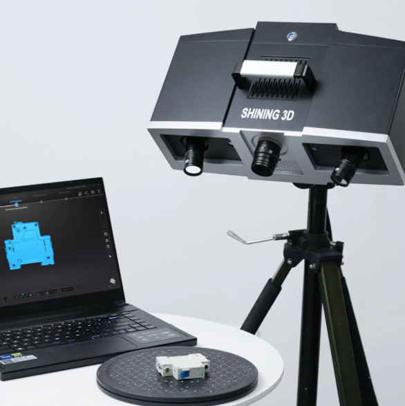
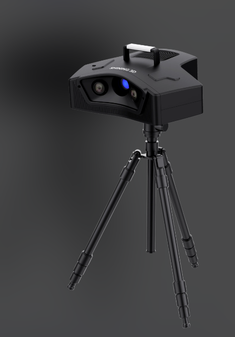
The scanner adopts a composite sensing scheme of dual-line laser and high-resolution camera, and is equipped with a self-developed real-time point cloud processing chip, which can realize real-time generation and denoising processing of million-level point cloud data per second, obtaining high-precision point cloud models without later time-consuming processing. Its IP67 fully sealed protection design can adapt to the dust, oil and humid environment of industrial workshops, ensuring stable long-term operation of the equipment. The device supports modular expansion, and additional scanning heads can be installed according to scanning needs to expand the scanning area and adapt to workpieces of different sizes. Compared with traditional coordinate measuring machines, this device can complete full-dimensional scanning without fixing the workpiece, greatly improving inspection efficiency, and supports real-time synchronization of scanning data to the industrial MES system to realize digital management of the production process.

https://globalsyt.oss-accelerate.aliyuncs.com/materials/182/0/20260306102754_69aa3baa65ae9.PNG

Product specifications:

The scanning accuracy can reach ±0.02mm per 1m scanning distance, meeting the high-precision inspection requirements of aerospace and precision machinery manufacturing. The maximum scanning area can reach 10m×8m, which can adapt to full-size scanning of large industrial workpieces. It uses Class 1 safety laser, which can be used safely in industrial workshops without additional protection. It is equipped with industrial Ethernet interface and PCIe expansion slot, which can be directly connected to industrial production systems. It is compatible with mainstream industrial CAD software such as SolidWorks and CATIA, and can directly generate standard data files for reverse modeling. The total power consumption is about 800W, supporting 24-hour continuous operation. It is equipped with an automatic calibration system, which can automatically complete equipment accuracy correction without manual adjustment by professional technicians. The whole machine weighs about 350kg, with a movable base, which can flexibly adjust the scanning position.

Product application:

It is mainly applicable to aerospace parts full-size inspection, large steel structure bridge survey, automobile body mold reverse modeling, heavy machinery workpiece size verification and other industrial scenarios. Aerospace manufacturers can use this equipment to complete high-precision inspection of turbine blades and fuselage components to ensure that parts meet design tolerances; large bridge construction teams can use it to complete on-site survey of steel structural components and generate accurate structural models for construction control; automobile mold manufacturers can complete reverse scanning of molds and quickly generate digital drawings for mold repair and replication. At the same time, the equipment supports offline scanning and real-time data backhaul, which can adapt to online quality inspection scenarios of industrial production lines.

Frequently Asked Questions (FAQ)

Q:What are the advantages of UAV-mounted 3D mapping scanners?
A:UAV-mounted 3D mapping scanners enable large-area surveying (up to 1km²/day) with centimeter-level accuracy. Featuring anti-vibration designs and GNSS synchronization, they're perfect for topographic mapping or mining volume calculations.

Company Profile

Business Type:
Manufacturer
Main Products:
Conventional surveying instruments,Electronic components,Architectural decoration instruments,
Year of Establishment:
2010
Number of Employees:
Address:
268-1 Youyi East Road, Beilin District, Xi'an, Shaanxi, China
Average Response Time:
Days

General Information

Business Type:
Manufacturer
Main Products:
Conventional surveying instruments,Electronic components,Architectural decoration instruments,
Year of Establishment:
2010
Number of Employees:
Management System Certification:
HACCP,TL900,QS9000,SA8000,ISO9001,ISO9004,ISO17799,ISO9000,ISO14000,ISO10441,ISO16949,TS16969,ISO19011:2000,OHSAS18001,Others
Address:
268-1 Youyi East Road, Beilin District, Xi'an, Shaanxi, China

Trade Capability

Main Markets:
北美,南美洲,东欧,东南亚,非洲,大洋洲,中东,东亚,西欧,中美洲,北欧,南欧,南亚,国内市场
Shipping Ports:
Export Volume:
Average Lead Time:
Days
Payment Terms:
T/T L/C MoneyGram PayPal D/P Western Union Others
Cooperation Mode:
OEM
Customization Supported:
Yes
Number of Foreign Trade Sales Staff:
Overseas Agent / Overseas Branch:
No

Company Show

Contact this supplier now
*From:
*To:
Mr. Zhang Jianmin
manager /
*Message:
Send
New Products
Product Groups
Find Similar Products By Category
scroll_to_top